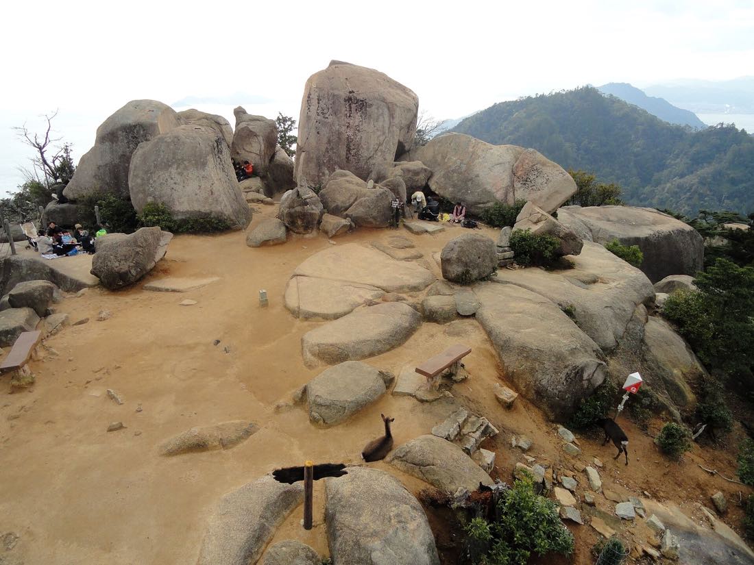
Mount Misen:
535 metres, three routes,
one real summit.
The best view in Hiroshima prefecture, and it is free. Three marked trails climb it — Daisho-in about 90 minutes, Momijidani about 2 hours, Omoto about 2 hours — and the summit observatory is 30 minutes beyond the top ropeway station, which is the fact that catches most visitors out.
Climb it. Mount Misen is 535m, the trails are free and well marked, and the 360-degree view over the Seto Inland Sea is the single best thing on Miyajima. Take the Daisho-in route up — about 90 minutes, the most direct, and it starts at the island's best temple — and come down through Momijidani in 75–90 minutes. If you would rather not climb, ride the ropeway up for ¥1,100 ($6.97) and walk down, but budget the extra 30 minutes each way from Shishiiwa to the actual summit.
Three ways up Mount Misen, compared
The routesTimes are for a reasonably fit adult walking steadily, without long stops. Add 20–30 minutes in July and August humidity, and take more water than you think — there is very little on the trails.
| Route | Time up | Character | Use it for | Verdict |
|---|---|---|---|---|
| Daisho-in | ~90 min | The most direct. Stone steps almost the whole way, steady and relentless rather than steep in bursts. Starts at Daisho-in temple. | Going up. Shortest, and the temple at the trailhead is worth 45 minutes on its own. | WORTH IT |
| Momijidani | ~2h | Through the maple valley then up the wooded flank. Shaded, scenic, more varied underfoot, and it passes close to the ropeway line. | Coming down. Ends at Momijidani Park, ten minutes from the shrine. | WORTH IT |
| Omoto | ~2h | The quiet one, on the western side. Fewest people, some forest, less obvious payoff along the way. | Second visits and anyone who wants the island to themselves. | DEPENDS |
| Ropeway to Shishiiwa | ~15 min riding | Two stages from Momijidani with a change at Kayatani. Stops at about 430m — not the top. | Saving your legs, at ¥1,100 one way. Still 30 minutes of rock to the summit. | DEPENDS |
The pairing that works best: up Daisho-in, down Momijidani. You get the temple, the shortest climb, the summit, and a descent that lands you back beside the shrine — about 4 to 4.5 hours all in, including time at the top.
Shishiiwa is not the summit
The distinction that mattersThe ropeway's upper station sits at about 430m. The summit observatory is at 535m, and the walk between them is roughly 30 minutes each way over granite steps and exposed rock.
That gap is where the disappointment lives. Visitors ride up, take the view from the Shishiiwa platform, ride down and report that Mount Misen was pleasant but oversold. The Shishiiwa view is good. The summit view is the one — open in every direction over the islands of the Seto Inland Sea, with the observatory deck at the top and, on a clear winter day, mountains on the far shore.
The path between them is not technical: stone steps, some rock, a short descent and re-climb through a saddle, past the balanced boulders the mountain is known for. Allow an hour for the return walk from Shishiiwa, plus 20 minutes at the top — and allow for the detour currently in place near the summit.
The Reifudō hall on Mount Misen burned down on 20 May 2026, and with it the shelter of the 1,200-year 「消えずの火」 — the flame said to have been lit by Kūkai, and the source flame for the Peace Park's Flame of Peace. Nobody was hurt and the mountain did not burn. The trails and the ropeway are open, but there is a detour near the summit, the temple has announced no rebuilding plan, and it has not said whether the flame itself survived. Almost every English guide still tells you to go and see it.
That is the single biggest change to Mount Misen in a generation and almost nothing written in English reflects it. Guides still send readers up to see the flame; the hall it burned in is gone, the reception office with it, the Reifudō–Sankidō path is closed, and the temple has not said what happens next. The trails, the ropeway and the summit view are all open and unaffected — go, and go knowing what is and is not there.
If you ride up on a round-trip ticket, that hour has to fit inside the 16:30 last descent — which is precisely why we tell you to buy the ¥1,100 single and walk down instead. Walking removes the deadline and the second fare in one decision.
Should you climb it?
Who it suitsMount Misen, practically
Plan your visitThe timing is what people get wrong.
Misen is a self-guided walk in every practical sense — the routes are signed, the steps are maintained, and you do not need a permit or a guide to reach the top. Where a guided hike earns its money is on a compressed itinerary, where somebody else owns the ferry times, the ropeway queue and the last descent. Prices and ratings are not published here because we could not verify them; check the listing for current figures.
See Misen hiking toursMount Misen questions
FAQPage schema pairedHow long does it take to climb Mount Misen?
About 90 minutes up the Daisho-in route, about 2 hours by Momijidani or Omoto, and 75–90 minutes back down. A full circuit — up the temple route, summit, down through the maple valley — runs 4 to 4.5 hours including 20 minutes at the top.
Which route up Mount Misen is best?
Daisho-in going up and Momijidani coming down. Daisho-in is the shortest at about 90 minutes and starts at the island's best temple; Momijidani is shadier, more varied and finishes ten minutes from the shrine. Omoto is the quiet third option and takes about 2 hours.
Is Mount Misen difficult?
It is a stairclimb, not a scramble: 535m of ascent on maintained stone steps with no exposure and no equipment needed. The difficulty is heat and repetition — in August, with a mean temperature of 28.5°C and 69% humidity, most people find the last 30 minutes hard regardless of fitness.
Do I need the ropeway to reach the summit?
No. Every route on this page reaches the summit on foot for nothing. The ropeway saves you the climb for ¥1,100 one way but stops at Shishiiwa, 30 minutes short of the top, so it never removes the final walk.
Is the view from the top worth it?
Yes — 360 degrees over the Seto Inland Sea and its islands from a 535m observatory, and it is the best view in the prefecture. The Shishiiwa platform 100m lower is good but partial, and confusing the two is the most common reason people report being underwhelmed.
What should I take up Mount Misen?
Water — at least a litre per person in summer, because there is very little on the trails — shoes with grip, and a phone torch if you are climbing after 15:00. There are toilets and a small rest house near the summit, but do not plan a meal around them.
Can I climb Mount Misen and still catch the last ferry?
Easily, if you start before 14:00. Ferries run into the evening and the crossing is 10 minutes, so the binding constraints are daylight and the 16:30 ropeway descent, not the boats. If you are walking down, allow 90 minutes from the summit plus 15 minutes to the pier.
Can I still see the eternal flame on Mount Misen?
No — the Reifudō hall that sheltered it burned down on 20 May 2026, along with the Misen reception office, and the temple has not confirmed whether the 1,200-year flame itself survived. Debris was cleared by 28 May, the trails and ropeway are open, and there is a detour near the summit where the Reifudō–Sankidō path is closed. No reconstruction plan has been announced.
Is Mount Misen still open after the fire?
Yes. Nobody was hurt, the mountain did not burn, and all three walking routes plus the ropeway are running normally. The only practical effect on your day is the detour near the top and one fewer thing to see when you get there — the 535m summit view is unaffected.
Are there monkeys on Mount Misen?
The island's monkey park closed years ago and monkeys are no longer a feature of a Misen climb; the animals you will meet are deer, mostly below 200m. Keep paper, maps and tickets zipped away — that is the only wildlife precaution the mountain actually needs.